|
|
Geography and Natural Resources |

Land and Resources
Puerto Rico is one of the larger islands of the West Indies, and the commonwealth also includes several small islands, such as Desecheo, Mona and Monito Islands to West (not shown on the map below); and Culebra, and Vieques to the East. The islands of Desecheo, Mona and Monito, are unhabited and are officially declared wildlife sactuaries. Puerto Rico is roughly rectangu
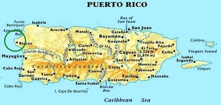 lar in shape; its greatest east to west distance is about 180 km (about 110 mi), and its extreme north
to south distance is about 65 km (about 40 mi). The highest point is 1338 m (4389 ft), atop Cerro de Punta. Puerto
Rico has an area of 9104 sq km (3515 sq mi). Its coastline measures some 501 km (some 311 mi).
lar in shape; its greatest east to west distance is about 180 km (about 110 mi), and its extreme north
to south distance is about 65 km (about 40 mi). The highest point is 1338 m (4389 ft), atop Cerro de Punta. Puerto
Rico has an area of 9104 sq km (3515 sq mi). Its coastline measures some 501 km (some 311 mi). Physical Geography
Puerto Rico is mountainous. The Central Mountains (Cordillera Central) form an east to west backbone that extends almost the entire length of the island. The average elevation of these mountains, which include the Cordillera Central and the Sierra de Luquillo, is about 915 m (about 3000 ft). Although the mountains and adjacent foothills cover most of Puerto Rico, on the northern side of the island lies a coastal plain up to about 19 km (about 12 mi) wide, and a narrower coastal plain up to about 13 km (about 8 mi) wide extends along the southern coast. For most of its length the mountain system is nearer the southern coast than the northern coast, and the slopes are generally steeper on the southern side. At the eastern end of the island, however, the mountains curve toward the northeastern corner.
Water Resources
Puerto Rico has many relatively short rivers and streams. Some of the rivers are dammed for hydroelectric power and thus have small lakes along their courses. One such body of water is Lago de Yauco, on the Yauco River. The longest river is the Grande de Arecibo, which flows to the northern coast. Other rivers include the Grande de Añasco, Bayamón, Cibuco, Culebrinas, and La Plata. None of the rivers is navigable by large vessels."
Mineral Resources
Puerto Rico's mineral deposits include limestone, glass sand, clay, copper, cobalt, chromium, nickel, iron ore, and peat. Great deposits of copper are in the central region near Adjuntas and Utuado."11
If you are interested in knowing more about Puerto Rico, take a few minutes to look through our Book Store. Here you you will find a lot more information on the history, culture, and other topics of interest about Puerto Rico for the vacationer, or the researcher.
We also recommend a visit to some great work by Professor Peter Johnson of the Illinois Institute of Technology. Take some time to visit his Western Puerto Rico tour pages at Northwest PR Tour and Southwest PR Tour, they also contain some great road maps!. Also visit the web pages created by a very proud Puerto Rican, and Master Navigator, Captain Jorge Gonzalez.
Want to see a real road map of Western Puerto Rico? Check out our scanned map sections of Western Puerto Rico. This road map is copyrighted by 'The H.M. Gousha Co.' whose permission was sought to duplicate this section of their map on our web site.
Return to Home Page...